APE establishes pavement evaluation mapping standards in support of AFCEC’s mission to provide warfighters and major commands with timely and accurate airfield pavement evaluations. Engineers are able to more efficiently manage pavements and allow planners to make accurate mission determinations in expeditionary environments worldwide.
In 2012, the Air Force Civil Engineer Center (AFCEC) wanted to improve their APE processes and systems to further support their mission of providing warfighters and major commands with timely and accurate airfield pavement evaluations. The solution would then allow engineers to more efficiently manage manage pavements, and allow planners to make accurate mission determinations in expeditionary environments worldwide.
APE was developed as an Autodesk Map 3D plug-in and utilizes data from PAVER/PCASE in conjunction with GeoBase spatial data to provide a set of comprehensive maps used in pavement analysis and survey reports. The APE data model was implemented as a standard Autodesk Industry Model that promotes data sharing between Air Force software applications, such as the Geospatial Expeditionary Planning Tool (GeoExPT).
The industry model design allows for spatial database management, workflows, and feature rules that apply DoD standards and requirements within the industry model and benefit the APE evaluation team in the overall process.
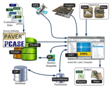
By correlating authoritative source information from past pavement evaluations with new surveys, the APE Toolkit allows you to perform updates for recently completed inventories, examine issues and/or changes identified, and further analyze airfields for their condition. Custom topology tools allow you to add, modify, validate and fix errors through the use of this simple and easy to use toolkit. Users are also able to symbolize conditions and develop many different types of layouts to collaborate on their findings.
Correlates information from PAVER/PCASE in conjunction with GeoBase spatial data
Offers a set of integration workflows to bring in existing inventory data
Links existing geospatial data to valuations gathered from CRG, Air National Guard Teams, RED HORSE, and AFCENT
Links standard map templates to existing pavement evaluation report spreadsheets
Links each base map with a central pavement evaluation database
Provides powerful topology and editing tools